


WASHINGTON 2, Brown County, Indiana
About
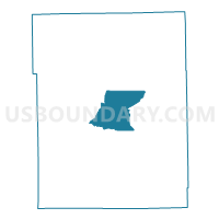
Outline

Summary
| Unique Area Identifier | 576503 |
| Name | WASHINGTON 2 |
| County | Brown County |
| State | Indiana |
| Area (square miles) | 13.98 |
| Land Area (square miles) | 13.93 |
| Water Area (square miles) | 0.05 |
| % of Land Area | 99.62 |
| % of Water Area | 0.38 |
| Latitude of the Internal Point | 39.19643410 |
| Longtitude of the Internal Point | -86.22221610 |
Maps


Graphs
Select a template below for downloading or customizing gragh for WASHINGTON 2, Brown County, Indiana


Neighbors
Neighoring Voting District (by Name) Neighboring Voting District on the Map
- HAMBLEN 1, Brown County, IN
- JACKSON 2, Brown County, IN
- VAN BUREN 1, Brown County, IN
- WASHINGTON 1, Brown County, IN
- WASHINGTON 3, Brown County, IN
- WASHINGTON 4, Brown County, IN
Top 10 Neighboring County Subdivision (by Population) Neighboring County Subdivision on the Map
- Washington township, Brown County, IN (4,896)
- Hamblen township, Brown County, IN (4,336)
- Jackson township, Brown County, IN (4,002)
- Van Buren township, Brown County, IN (2,008)